
The Settlement of Treeve Church Town
Name recorded as Treyuf in 1334, Treruffe / treyeuff in 1668 and Treeve or Trerise in 1825. This last one comes from Ref. x573/82 at the Cornwall Record Office.
From Tre meaning Farm and possible personal name
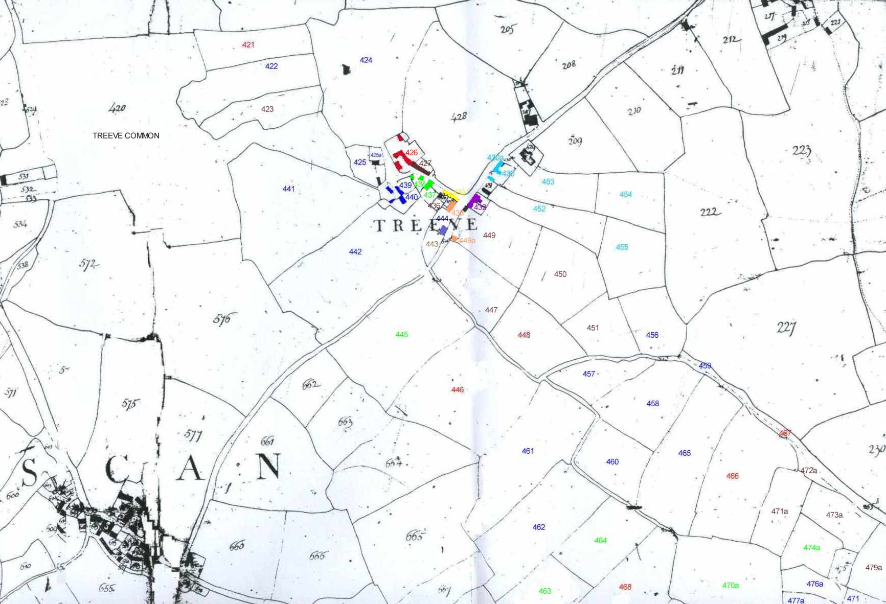

Click on map
| land owner | land worked by | Number on Map | Name & Description | State of Cultivation | Statute Measure
a r p |
|
429 |
Church Yard | 0 0 38 | |||
|
Total Area 0a 0r 38p Rent £0 |
|||||
| land owner | land worked by |
Number & colour on Map |
Name & Description | State of Cultivation | Statute Measure
a r p |
| Henry Hodge Trudgeon | Richard Botheras | 430a | Wastrel adjoining Church Yard | Waste | 0 0 06 |
| Pic | 430 | First & Last Inn | Inn | 0 0 25 | |
| Pic | 431 | Stable & Waste adjoining Road | Homestead | 0 0 12 | |
| 452 | Long Meadow | Arable | 1 0 20 | ||
| 453 | Square Meadow | Arable | 0 3 37 | ||
| 454 | Square Meadow | Arable | 1 0 24 | ||
| 455 | Five Sides | Arable | 1 1 32 | ||
| Total Area 4a 3r 36p Rent £1 - 12s - 9d | |||||
| land worked by |
Number & colour on Map |
Name & Description | State of Cultivation | Statute
Measure
a r p |
|
| Cartaret Ellis Esq. Leasee John William Stevens | Mathew Daniel | 421 | Gwel Lodn | Arable | 1 1 02 |
| Pic 1. 2. | 426 | Dwelling, Outbuildings, Town Place & Mowhay | Homestead | 0 1 16 | |
| 446 | Errow Veor | Arable | 3 2 32 | ||
| 448 | Park an Grouse | Arable | 1 2 30 | ||
| 466 | The Wyth | Arable | 3 0 0 | ||
| 467 | Part of Lane | Waste | 0 0 16 | ||
| 468 | Errow Veor | Arable | 3 0 17 | ||
| 469 | Errow Veor | Arable | 2 0 36 | ||
| 472 | Hallen Moor | Arable | 2 0 24 | ||
| Total Area 17a 2r 13p Rent £3 - 4s - 3d | |||||
| land owner | land worked by |
Number & Colour on Map |
Name & Description | State of Cultivation | Statute
Measure
a r p |
| John Gilbert (Davies) Esq. | James Wallis | 422 | Gweal Todn | Arable | 1 3 02 |
| 424 | Gweal West | Arable | 4 1 34 | ||
| 425 | Garden | Arable | 0 1 08 | ||
| 425a | Barn, Mowhay, Fold & Shelter | Homestead | 0 0 20 | ||
| Pic 1. | 439 | Farm House & Homestead | Homestead | 0 0 32 | |
| Pic | 440 | Mowhay, Stable Etc. | Homestead | 0 0 30 | |
| 441 | Dorlien | Arable | 4 1 17 | ||
| 442 | Home Field | Arable | 4 1 24 | ||
| 456 | Godirran | Arable | 1 0 12 | ||
| 457 | Little Wyth | Arable | 0 3 35 | ||
| 458 | Wyth Croft | Arable | 1 3 12 | ||
| 459 | Half of Lane | 0 0 13 | |||
| 460 | Wyth Croft | Arable | 1 1 10 | ||
| 461 | Errow Veor | Arable | 3 1 05 | ||
| 462 | Errow Veor | Arable | 3 0 0 | ||
| 465 | Great Wyth | Arable | 2 3 18 | ||
| 473 | The Crabmack | Arable | 1 3 35 | ||
| 474 | The Crabmack | Arable | 2 0 11 | ||
| 475 | Hallan Moor | Arable | 2 1 08 | ||
| 476a | Orchard | Arable | 0 2 00 | ||
| 477a | Hallan Moor | Arable | 0 1 22 | ||
| 471 | Hallan Moor | Water & Morass | 1 1 15 | ||
| Total Area 38a 3r 3p Rent £7 - 3s - 5d | |||||
| land owner | land worked by | Number & colour on Map | Name & Description | State of Cultivation | Statute
Measure
a r p |
| John Saundry of St Just | David Mathew | ||||
| 437 | Mowhay Barn Etc | Homestead | 0 0 17 | ||
| Pic | 438 | Dwelling & Wastrel | Homestead | 0 0 14 | |
| 445 | Home Field | Arable | 3 2 36 | ||
| 463 | Errow Veor | Arable | 1 2 08 | ||
| 464 | Errow Veor | Arable | 1 3 10 | ||
| 470a | The Crabmack | Arable | 2 1 28 | ||
| 474a | Hallow Moor Meadow | Arable | 0 3 16 | ||
| 470 | Round Moor | Morass | 1 0 00 | ||
|
Total Area 11a 2r 9p Rent £0 - 12s - 5d |
|||||
| land owner | land worked by | Number & colour on Map | Name & Description | State of Cultivation | Statute
Measure
a r p |
| John Short | Himself | ||||
| 433 | A Cott House in Church town | Homestead | 0 0 01 | ||
|
Total Area 0a 0r 1p Rent £0 |
|||||
| land owner | land worked by | Number & color on Map | Name & Description | State of Cultivation | Statute
Measure
a r p |
| Henry
Hodge Trudgeon
Lessee Thomas Hutchins |
Himself | ||||
| Pic Pic2 | 432 | Dwelling & Garden in Church Town | Homestead | 0 0 24 | |
|
Total Area 0a 0r 24p Rent £0 |
|||||
| land owner | land worked by | Number & colour on Map | Name & Description | State of Cultivation | Statute
Measure
a r p |
| William Johns | Himself | ||||
| 443 | Garden adjoining the Baptist Meeting House | Garden | 0 0 29 | ||
| Total Area 0a 0r 29p Rent £0 - 0s - 10d | |||||
| land owner | land worked by | Number on Map | Name & Description | State of Cultivation | Statute
Measure
a r p |
| James
Trembath
Lessee Stevens |
Daniel Mathew | 428 | Field Adjoining Mayon House | Arable | 0 4 18 |
| Total Area 0a 0r 18p Rent £1 - 1s - 8d | |||||
|
Land Owner |
Number on Map | Name & Description | State of Cultivation | Statute
Measure
a r p |
|
| Gilbert, Ellis, Wallis, James Saundry, John Stevens lessee of Ellis part | 420 | Treeve Common | 12 3 36 | ||
| land owner | land worked by | Number & colour on Map | Name & Description | State of Cultivation | Statute
Measure
a r p |
| James Wallis | Himself | ||||
| 427 | Dwelling & Mowhay | Homestead | 0 0 12 | ||
| 447 | Park Grouse | Arable | 1 2 00 | ||
| 449 | The Town Field | " | 1 2 00 | ||
| 450 | Middle Park Grouse | " | 1 3 04 | ||
| 451 | Further Park Grouse | " | 0 3 39 | ||
| 423 | Guel Todn | " | 1 0 12 | ||
| 471a | Meadow | " | 1 0 14 | ||
| 472a | Waste Outside | Waste | 0 0 15 | ||
| 473a | Meadow | Arable | 0 3 38 | ||
| 475a | Garden | Garden | 0 0 22 | ||
| 479a | Square Field | Arable | 1 1 38 | ||
| 436 | Fold & Outhouse | Homestead | 0 0 06 | ||
| Total Area 10a 3r 0p Rent £2 - 3s - 2d | |||||
| land owner | land worked by | Number & colour on Map | Name & Description | State of Cultivation | Statute
Measure
a r p |
| James Wallis | Baptists | ||||
| Pic | Baptist Meeting House | 0 0 02 | |||
| Total Area 0a 0r 2p Rent £0 | |||||
| land owner | land worked by | Number & colour on Map | Name & Description | State of Cultivation | Statute
Measure
a r p |
| James Trehare | Himself | ||||
| Pic | Blacksmith's Shop | 0 0 01 | |||
| Total Area 0a 0r 1p Rent £0 | |||||
| land owner | land worked by | Number & colour on Map | Name & Description | State of Cultivation | Statute
Measure
a r p |
| Robert Wallis | Themselves | ||||
| & James Trehare | Pic | Dwelling & Plot | Homestead | 0 0 04 | |
| Total Area 0a 0r 4p Rent £0 | |||||

First & Last Inn No 430 Return to Table

No 431 Return to Table


No 426 Dwelling & Quaker Meeting House. Return to Table

No 438 Dwelling Return to Table

No 432 + 432b below Return to Table

The dower house. Built in 1748 for Mary Vingoe, nee Daniel 1705 - 1794. she was the widowed mother of Richard Vingoe who farmed at Trevilley and owned the First & Last Inn. Her grandson William was the last male heir to this Vingoe line and he died of consumption in1800 aged 33 leaving two infant daughters. One of these Mary Vingoe, married, Henry Hodge Trudgeon and the Sennen Lands belonging to this branch of the Vingoe's passed to him.


No 439 & 440 Return to Table 439 440

No 444a the old building with the white chimney was the Baptist meeting house in 1838 Return to Table

No 449a Return to Table
James Trehare's blacksmith shop.
Sandra and George Pritchard are the authors of original work on this site. They give permission to copy and use this information on the following conditions.
![]()